
Overview
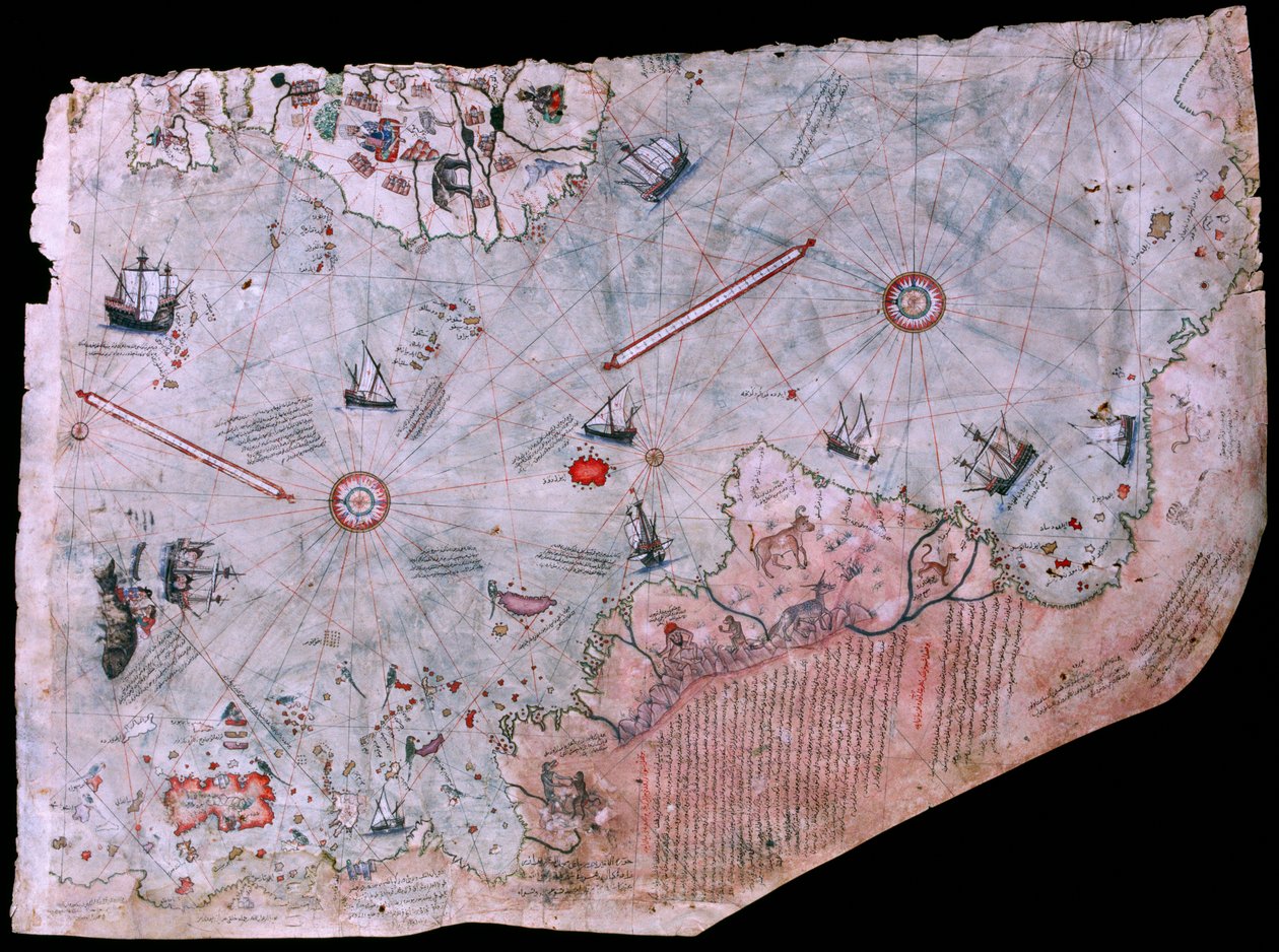
The Piri Reis world map of 1513 is one of the most important surviving cartographic artifacts of the Age of Discovery. Preserved today in the Topkapı Palace Museum Library, the surviving fragment is a portolan-style world map on gazelle-skin parchment, signed by the Ottoman admiral and cartographer Piri Reis himself. Its fame rests on a rare combination of things that are all true at once: it is materially real, historically important, visually striking, and still wrapped in layers of overinterpretation.
What makes the map matter is not only that it shows parts of the newly encountered Atlantic world very early. It matters because it captures a moment when geographic knowledge was being assembled from fragments, rival empires, inherited traditions, and newly seized reports. The Piri Reis map is less a single revelation than a stitched world, an attempt to fuse old cosmologies and new coastlines into one usable picture.
Origins and Background
The map was drawn in 1513, and only its western third survives today. UNESCO’s Memory of the World nomination identifies it as the 1513 world map preserved in the Topkapı Palace Museum Library, notes that it was rediscovered there in 1929, and describes it as a unique and light-sensitive object not kept on permanent display. The surviving fragment shows the Atlantic system, including parts of Europe, Africa, and the Americas.
Piri Reis also told later readers, in his own marginal notes, how the map was compiled. A standard English translation of one major inscription says he drew from “about twenty charts and mappae mundi,” along with eight “Jaferiyes,” an Arabic map of India, four Portuguese maps, and a map by Columbus for the western regions. Whatever the exact identity of each source, the point is clear: the map was presented as a synthesis, not as a solitary original vision.
That background is crucial because it shifts the meaning of the artifact. The Piri Reis map is not impressive because one man somehow knew everything. It is impressive because it shows how knowledge moved across cultures, languages, and political boundaries. The real story is not isolated genius so much as archival convergence.
What It’s Known For
The Piri Reis map is best known for a few specific things:
- Being one of the earliest surviving world maps to incorporate the newly encountered Atlantic world in such an ambitious way. UNESCO calls it the earliest cartographic record of Columbus’s oceanic voyages and the oldest surviving cartographic record of the New World discoveries.
- Its unusually detailed source note, which openly claims compilation from multiple charts and traditions, including Portuguese and Columbian material.
- Its portolan-style structure, with compass roses, rhumb lines, and navigational features characteristic of maritime charting in the transition between medieval and early modern mapping.
- Its rich visual program of ships, rulers, beasts, and mythic or semi-mythic imagery, which UNESCO notes is unusually abundant for a map of its kind.
- The long afterlife of fringe claims that it shows Antarctica before its official discovery, a reading that has become culturally famous but is not supported by mainstream cartographic scholarship.
What makes the map distinct is that it is not only geographic. It is interpretive. It does not merely record coasts. It frames them with inherited legend, symbolic imagery, and the authority of gathered sources. It sits halfway between navigational instrument and civilizational collage.
The Core Idea
The deeper signal behind the Piri Reis map is that discovery is often less about seeing something first than about assembling enough fragments to make a new world thinkable.
That is what the artifact really represents. The map does not emerge from nowhere. It presents itself as a built object, made from older charts, borrowed coastlines, inherited frameworks, and translated reports. In that sense, the map is not just a picture of the world. It is a record of how worlds are synthesized under pressure, when old systems are no longer sufficient but new systems are still unstable.
This is why the map still exerts such force. It gives the impression of hidden continuity, of knowledge moving through lost charts and partial copies rather than arriving in a single clean breakthrough. That atmosphere has helped fuel both serious scholarship and fringe speculation. The same feature that makes the map historically fascinating also makes it vulnerable to myth.
Perspectives and Interpretations
Supporters of the map’s high historical importance tend to focus on its value as a convergence artifact. UNESCO explicitly treats it as a landmark work of world cartographic history and emphasizes its importance for preserving the earliest cartographic record of Columbus’s voyages and very early depictions of the New World. In that reading, the map matters because it preserves a chain of geographic transmission that would otherwise be mostly lost.
A second interpretive lane emphasizes the Columbian connection. McIntosh’s work, as summarized in later publications and your original post, argues that parts of the Caribbean and nearby regions likely preserve features derived from an early Columbian template. That matters because Columbus’s own maps do not survive in the same form, making the Piri Reis map valuable not just as an Ottoman artifact but as indirect evidence for earlier Atlantic mapping.
The most famous popular interpretation is the Antarctica claim. In that reading, the southern landmass on the map is not a conventional southern continent but an image of Antarctica, sometimes even Antarctica without ice. That idea was pushed most famously through the Mallery and Hapgood line of argument in the twentieth century.
Mainstream critical readings push back hard on that conclusion. The Aramco World review of the Hapgood hypothesis describes the Antarctica portion of the theory as the weakest part, noting that the supposed Antarctic coast is connected to South America, omits key southern passages, and may align more plausibly with distorted South American geography instead. McIntosh’s later summary likewise treats the southern land as part of a conventional Southern Continent tradition and notes that Piri Reis was not alone in attaching such a landmass to South America.
The strongest balanced position is therefore narrower and cleaner: the map is historically remarkable, materially authentic, and genuinely important, but it does not require lost Ice Age civilizations or ice-free Antarctica to remain astonishing. Its real significance already stands without those additions.
Strengths and Limitations
The map’s greatest strength is that its core historical case is extremely solid. UNESCO records that its authenticity has not been seriously disputed, that Piri Reis identifies himself on the map, and that its technical features match the portolan standards and cartographic practices of its period. This is not a fake relic propped up by modern fantasy.
Another strength is that the marginal notes make the artifact unusually transparent about its own making. Many famous maps survive without clear commentary on sources. The Piri Reis map instead announces its compilation method, its source base, and its ambition. That gives historians something far more valuable than mystery alone: it gives them a statement of method from the mapmaker himself.
The limitations are equally important. Only a fragment survives, not the full circular composition. That means every interpretation is working with absence as well as presence. The missing parts matter, especially when later readers try to overbuild conclusions from the southern edge or from the hypothetical original center.
There is also a pattern-hunger problem. Because the map is beautiful, early, and composite, it invites people to treat every anomaly as encoded proof of hidden knowledge. But the Antarctica reading shows the danger of that impulse. Extraordinary claims about ancient cartographers or forgotten global civilizations still lack the extraordinary proof they would require.
Broader Implications
The Piri Reis map matters because it reveals something deeper about knowledge itself: maps are never just records of space. They are records of contact, translation, trust, myth, error, and ambition.
That is why the artifact still feels modern. It shows an information world already saturated with partial sources and interpretive risk. Piri Reis was not drawing from perfect firsthand survey data. He was integrating reports, inherited models, and rival traditions into a working synthesis. In a different register, that is still how knowledge systems operate now.
It also matters because it shows how myth grows around real objects. The map’s true history is already rich enough to be compelling, but its survival as a fragment and its southern ambiguities helped create a second life in alternative-history culture. That tension, between authentic wonder and overreach, is part of what makes it such a strong Dossier subject for The Galactic Mind.
For The Galactic Mind, the broader lesson is clear: some of the most magnetic artifacts are not mysterious because they prove the impossible. They are mysterious because they preserve the exact moment when the world was becoming bigger than the systems built to describe it.
The Galactic Mind Perspective
The disciplined read on the Piri Reis map is not that it secretly solves Antarctica, Atlantis, or a forgotten global civilization. It is that it embodies the unstable threshold where inherited cosmology met new geography, and where synthesis itself became a form of power.
That makes it more interesting, not less. The map does not need impossible claims to feel charged. Its real force lies in showing how human beings build coherence from fragments, and how later generations keep projecting new longings onto the gaps. The artifact is not only a chart of coastlines. It is a chart of interpretive desire.
Open Thread
If the Piri Reis map remains so compelling even after the Antarctica myth is stripped away, then what is its deepest hold on us: the coastlines it shows, the sources it implies, or the possibility that history always preserves more hidden relay points than we first imagine?
Sources / Receipts
- UNESCO Memory of the World nomination for The Piri Reis World Map (1513).
- Translation of Piri Reis’s marginal source note.
- Gregory C. McIntosh on why the map is important and on the Columbian connection.
- Scholarly and historical criticism of the Hapgood Antarctica theory.
- Your original Galactic Mind post for baseline framing and emphasis.
What do you think? Drop your thoughts in the comments


Discussion