
The Yonaguni Monument looks built.
That is the observation that starts almost every argument about it—and almost none of the proof.
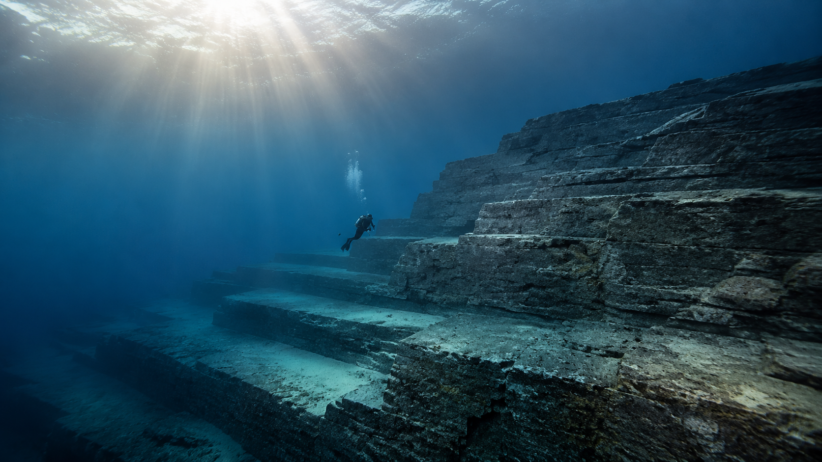
Beneath the water off Japan’s westernmost inhabited island, a mass of sandstone rises in broad terraces, sharp faces and long horizontal planes. From certain angles it resembles a stepped monument, a ceremonial platform or the exposed foundation of a drowned city. The uncanny impression is real. The dispute is over what that impression means.
What makes Yonaguni matter is not that it has been proven to be a lost city. It has not. The site matters because it sits in the unstable space where geometry, geology and imagination begin to look like the same thing. It asks how we recognize intention in matter and what evidence must exist before resemblance becomes archaeology.

Overview: What This Is
The Yonaguni Monument is a submerged bedrock formation off the southern coast of Yonaguni Island, at the far western end of Japan’s Ryukyu chain, roughly east of Taiwan. Japan’s National Tourism Organization describes the main rectangular formation as approximately 100 meters long, 60 meters wide and 25 meters high. Its upper surfaces lie in relatively shallow water, but strong currents make the site a dive for experienced visitors.
The word monument can be misleading. It is the popular name for a landform, not an archaeological designation. The site has not yielded a verified construction sequence, cultural layer, tool assemblage or body of artifacts establishing it as a building. In the official and current reporting reviewed for this Dossier, Japanese cultural authorities have not recognized it as a cultural property. Those facts do not make every form of ancient human use impossible, but they define the present evidentiary boundary.
What is documented is already striking. Divers encounter flat terraces, steep scarps, narrow channels, ledges and corners cut through a layered rock mass. Some features have acquired architectural names—the Main Terrace, the steps, the road, the stadium, the Twin Megaliths but those labels describe visual analogies. They are not independently established functions.
Yonaguni therefore begins with a necessary separation. The stone is real. The geometry is real. The architecture is an interpretation.

Origins and Background
Local diving operator Kihachiro Aratake encountered the formation in 1986 while exploring the waters off Yonaguni’s southern coast. This origin matters because the site did not first enter public knowledge through a controlled archaeological survey. It emerged through dive culture: an extraordinary underwater landscape was found, named and photographed, and only then became a candidate ruin.
Marine geologist Masaaki Kimura of the University of the Ryukyus became the best-known advocate of an artificial origin. After years of diving and mapping, he interpreted parts of the site as roads, walls, plazas, a stadium, a castle-like complex and carved animal or human forms. In a 2003 paper, he described the formation as an artificial, stepped monument around 10,000 years old and compared its main structure to a large gusuku, the castle tradition of the Ryukyus.
The dates attached to that interpretation have not remained stable. Later reporting described Kimura arguing for a city at least 5,000 years old, while other public accounts placed construction closer to 2,000 or 3,000 years ago and invoked tectonic submergence. A changing estimate is not disqualifying by itself; research often revises dates. Here, however, the shifts expose the underlying problem: there is no accepted archaeological deposit at the monument that directly dates human construction.
The physical setting supplies a competing explanation. Yonaguni stands in a tectonically active region near the Ryukyu subduction system and Okinawa Trough. Geological work on the island describes widespread Miocene sandstone of the Yaeyama Group, with mudstone layers, faults and numerous joints. At Sanninudai and other onshore locations, the same island geology produces flat surfaces, angular fractures and step-like forms without construction.
The site soon moved beyond geology. Books, documentaries and online media connected it to Mu, Lemuria, Atlantis and an advanced Ice Age civilization. Those frames made Yonaguni globally legible: the underwater terraces were no longer just an unusual coastal landform, but a possible surviving fragment of erased history. That influence is real. The evidence for those civilizations at Yonaguni is not.

What It Is Known For
Yonaguni is known first for its visual force. Underwater light simplifies surfaces. Distance softens irregularities. A diver gives the stone scale, while the surrounding blue removes the ordinary landscape cues that might make the same strata easier to read on land. In a carefully framed photograph, the formation can look less like exposed bedrock than the flank of a stepped pyramid.
The apparent terraces are the site’s signature. Broad platforms end at near-vertical faces; horizontal bedding and cross-cutting joints can meet in corners that resemble masonry. Channels run through parts of the rock. Depressions have been described as post holes. Surface marks have been interpreted as quarrying traces, inscriptions or animal figures. Kimura assembled these forms into a larger architectural reading in which the names reinforce one another: once there is a road, a plaza and a stadium, the site begins to feel like a city.
Yet naming is not neutral. A channel becomes a road only when independent evidence indicates traffic, shaping or connection to a built environment. A ledge becomes a stair only when its dimensions, repetition, access and working marks distinguish it from joint-controlled erosion. A scratch becomes an inscription only when its morphology, pattern and context exclude ordinary abrasion, biological activity or fracture. Yonaguni is famous partly because descriptive language has often moved ahead of that verification.
The geology is less cinematic but more cumulative. Researchers have long noted that layered sandstone can split along bedding planes while vertical joints divide the rock into angular blocks. Faulting and earthquakes add fractures. Waves and strong currents remove loosened material, abrade exposed surfaces and exploit weaknesses. None of those processes alone needs to “carve a pyramid.” Together, over long intervals, they can leave terraces, scarps, channels and sharp-edged remnants.
A 2024 Japanese Association of Geographers conference study made this case with the most direct modern field program located for this Dossier. Hiroshi Kan and a multidisciplinary team combined multibeam bathymetry, repeated SCUBA surveys and a one-centimeter-grid photogrammetric model produced by an underwater ROV. They reported numerous flat-topped, ruin-like sandstone landforms around Yonaguni; observed exfoliation, abrasion, gravel production and pothole formation; and found the forms bounded by abundant joints in the Yaeyama Group. Their conclusion was that continuing weathering and erosion can create the ruin-like terrain. They also reported that no archaeological artifacts or human traces had been detected.
That source should be weighted carefully. It is a detailed conference abstract, not a full archaeological site report or the final word on every feature. But it is recent, method-specific and directly relevant. More importantly, it gives the natural interpretation positive evidence. The case is no longer merely that construction has not been proved. Researchers can identify the material, structures and active processes capable of producing the observed geometry.

The Core Idea or Signal
The deeper signal behind Yonaguni is this: geometry is not proof.
Human beings are extraordinarily sensitive to edge, symmetry, repetition and enclosure. Those abilities help us recognize shelter, tools, faces and traces of agency. They also create false positives. Nature generates columns, polygons, arches, terraces and straight fractures because physical systems have structure. A form can look intentional without containing an intention.
Archaeology is the discipline that moves from resemblance to context. A persuasive case for construction would not depend on the impression of one terrace. It would seek tool marks inconsistent with known erosion; detached and deliberately placed blocks; repeating measurements linked to function; cultural deposits; artifacts; quarry debris; datable material associated with modification; or spatial patterns that survive comparison with natural exposures. The more extraordinary the proposed civilization, the more of that connected material record we should expect.
This does not mean a natural formation is unimportant. Yonaguni may be more intellectually useful when read as geology that imitates architecture than as an architecture the evidence cannot yet support. It becomes a field test for epistemology: how quickly does wonder harden into a conclusion, and what would make us change our minds?
Perspectives and Interpretations
The artificial-monument interpretation
Kimura’s interpretation begins with concentration. He has argued that too many apparently meaningful features occur together to be accidental: terraces, channels, wall-like forms, quarry marks, carved motifs and a larger arrangement he reads as a ceremonial or defensive complex. A seismologist, Toru Ouchi, publicly supported that reading after diving the site. The strongest version of the claim treats Yonaguni as the remains of an ancient built environment submerged by sea-level or tectonic change.
The strength of this perspective is that it takes the full site seriously rather than explaining one photograph at a time. Its limitation is archaeological. The named features do not yet converge with a verified material culture, and several claimed carvings remain disputed visual interpretations. Kimura’s published 2003 conclusion is a primary record of his position; it is not independent confirmation of that position.
The geomorphological interpretation
The geology-first view explains the formation through the interaction of bedding, joints, faults, weathering and marine erosion. Robert Schoch, after multiple dives, concluded that the monument is primarily natural because the local rock separates cleanly in horizontal and vertical planes; he also compared it with related forms on land. His site-specific conclusion is notable because it runs against his own interest in very early monumental cultures.
More recent Japanese work strengthens that reading. Onshore research by Takayuki Ogata and colleagues documents Yaeyama Group sandstone, normal faults and numerous joints at Sanninudai. The 2024 seafloor survey then connects comparable geology to active underwater erosional processes and reports no detected artifacts or human traces. This does not mathematically exclude every human action. It does make natural formation the interpretation presently supported by the strongest positive evidence.
The human-modified natural formation
A hybrid possibility is often presented as the reasonable midpoint: perhaps geology made most of Yonaguni and ancient people used or lightly altered it. Schoch has publicly allowed this narrow possibility, describing the formation as overwhelmingly natural while suggesting that inhabitants could have admired, used or “touched up” parts of it.
Logical possibility, however, is not the same as an evidence-based compromise. Humans often use natural rock shelters, caves and terraces, so the hypothesis is plausible in the abstract. At Yonaguni it still needs positive evidence: a worked surface that resists geological explanation, an associated artifact, a cultural deposit or a reproducible pattern of modification. Until that appears, “partly modified” is a testable proposal—not a settled halfway answer.
The lost-civilization interpretation
The most expansive reading connects Yonaguni to Mu, Atlantis or an advanced civilization destroyed near the end of the Ice Age. It draws power from two real facts: coastlines were transformed by postglacial sea-level rise, and prehistoric humans in the Ryukyus were capable seafarers. In 2025, experimental archaeologists reported a successful 225-kilometer voyage from Taiwan to Yonaguni in a dugout canoe built with replica Paleolithic tools; companion ocean modeling found such a crossing feasible under ancient conditions with the right strategy.
That research corrects a dismissive assumption. People reached and navigated these islands long before complex states appeared, and their maritime capability should not be underestimated. But capability is not construction evidence. The voyage helps explain how humans could reach Yonaguni around 30,000 years ago. It does not connect those voyagers to the underwater formation, establish monumental architecture or validate a lost global civilization.
Strengths and Limitations
Yonaguni is stronger than many mystery subjects because the central object is not rumor. The bedrock can be revisited, surveyed and compared with onshore analogues. Divers have documented it for decades, and newer methods can record the seafloor in three dimensions at far higher resolution than a dramatic still photograph. The site is therefore capable of producing better evidence.
Its underwater setting also imposes real limits. Strong currents complicate access and fieldwork. Marine growth, changing visibility and artificial lighting alter the appearance of surfaces. Abrasion can create marks and erase older ones. Photographs select angles, and a named feature can bias what a later observer expects to see. These conditions do not prevent archaeology, but they raise the importance of systematic mapping, microscopic analysis, control samples and transparent data.
The evidence also has an asymmetry that should not be hidden behind the word controversial. The natural explanation is supported by mapped regional geology, onshore analogues and observed erosional processes. The constructed-site hypothesis is supported primarily by morphology and interpretation. No verified artifact, cultural layer or diagnostic tool mark has yet closed that gap.
At the same time, absence of recovered artifacts is not proof that no person ever stepped on, used or altered the landform when sea level and coastline were different. Underwater preservation is selective, and the precise sequence of subaerial and marine erosion remains worth studying. A rigorous conclusion can therefore be strong without becoming absolute: the formation is best explained as natural on current evidence, while limited human use remains an unverified possibility.
The site’s official status belongs in the same category of care. The absence of cultural-property recognition is relevant because it shows that Yonaguni has not met the institutional threshold of an established archaeological site. It is not, by itself, a geological argument. Administrative status should not be mistaken for scientific proof in either direction.
Broader Implications
Yonaguni reveals how easily an archaeological claim can be built from visual grammar. Once a ledge is called a stair and a channel is called a road, nearby features begin to organize themselves into a city. The pattern becomes cumulative in the mind before it becomes cumulative in the evidence. This is not fraud; it is how interpretation works. The discipline lies in noticing when language has begun doing more work than the material record.
The site also exposes an unhelpful opposition between respecting ancient people and accepting every claim made in their name. Paleolithic communities in the southern Ryukyus crossed dangerous water and occupied remote islands tens of thousands of years ago. Recognizing that sophistication does not require assigning them a monumental complex. In fact, insisting that Yonaguni must be a city can distract from documented human achievements that are already extraordinary.
Submerged prehistory is a genuine frontier. Postglacial sea-level rise inundated coastlines on which people traveled, gathered food and built settlements. Underwater archaeology has recovered real towns, harbors, landscapes and artifacts elsewhere because those sites contain context—not merely suggestive geometry. Yonaguni should encourage more careful exploration of drowned shelves, but it cannot stand in for the material record that exploration is meant to find.
There is also a lesson for an image-saturated culture. A single frame can make a fractured cliff look machined; a different angle can make it look ordinary. Online, the most architectural view will travel farther than the most diagnostic view. In an era of algorithmic repetition and generated imagery, provenance, scale, angle and comparison are not secondary details. They are part of the evidence.
The Reality Signal
What This Subject Represents
Yonaguni represents the boundary between pattern and intention. It is a place where nature produces a visual language humans associate with planning—levels, edges, thresholds and steps—and where the mind tries to recover a builder from the form.
Its importance does not depend on becoming a city. The formation is a material demonstration that reality can be highly ordered without being designed, and that a compelling perception can remain sincere even when its explanation changes.
What Reality Frame It Challenges
Yonaguni challenges two opposite habits. The first is the assumption that anything resembling architecture must have an architect. The second is the assumption that once geology offers an explanation, the subject becomes dull.
Both flatten the site. Nature is capable of structures that exceed our visual expectations, while human history is capable of complexity that deserves actual evidence rather than projection. The better frame holds wonder and method together: appearance opens the inquiry; context decides how far the claim can travel.
Why It Matters Now
The question is newly sharpened by better tools. Multibeam mapping, ROV photogrammetry and repeat dive surveys can test the monument as a landform rather than a collection of iconic photographs. Recent experimental archaeology also gives a more capable picture of Paleolithic seafaring in the region without turning that capability into evidence for a city.
Yonaguni matters now for a second reason. We increasingly encounter reality through selected or synthetic images. The site trains a useful reflex: before asking what a picture resembles, ask how it was made, what lies outside the frame and what independent evidence connects the visible pattern to the proposed cause.
What Remains Unresolved
The large-scale formation has a strong natural explanation, but several narrower questions remain open. Researchers could further reconstruct when particular surfaces were exposed to air, surf and deeper water; publish more complete high-resolution models; compare alleged tool marks with controlled natural surfaces; and test whether any small area preserves reproducible evidence of human use.
The unresolved question is therefore not whether the current record secretly proves a lost city. It does not. The useful question is whether future work can identify any human action within a landform whose overall architecture-like appearance is already well explained by geology.
The Galactic Mind Perspective
Yonaguni belongs in The Galactic Mind archive because it makes the act of interpretation visible.
We do not encounter the world as raw data. We encounter surfaces already filtered through expectation, analogy and story. Underwater, a terrace becomes a platform. A depression becomes a socket. A fracture becomes a wall. The mind is not making these shapes up; it is assigning them a cause.
That distinction is the entire Dossier.
The evidence now leans clearly toward a natural formation. Saying so does not require dismissing the people who first experienced the site as uncanny, nor does it close the door to every form of ancient use. It simply places the weight where the observations place it. Wonder with receipts is not weaker wonder. It is wonder that knows what it knows.
Perhaps the most consequential mystery at Yonaguni is not a lost civilization beneath the sea. It is why nature can imitate our visual language of building so convincingly—and why we are so ready to treat the imitation as memory.
The rocks are real. The geometry is real. The awe is real. The city, for now, is a story waiting for evidence.
Open Thread
If a landscape can trigger the certainty of architecture without supplying the evidence of occupation, what should carry more weight: the geometry we see, or the context we cannot find?
What do you think? Drop your thoughts in the comments ...
More in Dossier
- Sacsayhuamán and the Stone Intelligence of the Inca World — A grounded comparison in which architecture is certain but the full technical system remains partly unrecovered.
- Puma Punku and the Precision Problem of Ancient Stone — A companion investigation into how extraordinary geometry attracts unsupported lost-technology claims.
- Graham Hancock and the Lost Civilization Question — The broader cultural frame through which submerged landscapes are often turned into evidence for a vanished Ice Age civilization.
Sources / Receipts
- Hiroshi Kan et al. “Sandstone Erosional Landforms on the Seafloor Around Yonaguni Island: Shallow-Seafloor Geomorphology Using Multibeam Bathymetry, ROV Photogrammetry, and Diving Surveys.” Abstract presented at the Japanese Association of Geographers Spring 2024 meeting. This is the most direct recent field source used here; it reports the survey methods, active erosion and the absence of detected artifacts or human traces. It is a conference abstract, not a full site monograph. J-STAGE record and DOI.
- Takayuki Ogata, Makoto Otsubo and Hideyuki Itoh. “Geosites of Yonaguni Island Located at the Westernmost Point of Japan.” E-journal GEO 15, no. 1 (2020): 44–54. Used for the island’s Yaeyama Group sandstone, Sanninudai joints, normal faults and broader tectonic setting. J-STAGE article.
- Kiyotsura Yazaki. Geology of the Yonagunishima District. Geological Survey of Japan, 1:50,000 geological map, 1982. Used as the official geological mapping baseline. Geological Survey of Japan record.
- Tomohiro Toki et al. “Origin of Helium in Basement Rocks and Carbonate Veins in Yonaguni Island.” Geochemical Journal 58, no. 6 (2024). Used only for updated geological context: Yaeyama Group sandstone and mudstone, Ryukyu Group limestone and active fault systems. Open article and DOI.
- Masaaki Kimura. “Paleogeography of Ryukyu Islands and Submarine Ruins off Yonaguni, Okinawa, Southern Japan.” Journal of Fossil Research 36, no. 2 (2003): 33–42. Primary source for Kimura’s artificial-monument interpretation and early age estimate; not treated as independent archaeological confirmation. J-STAGE article.
- Julian Ryall. “Japan’s Ancient Underwater ‘Pyramid’ Mystifies Scholars.” National Geographic, September 19, 2007. Used for attributed claims by Kimura, Toru Ouchi and Robert Schoch, the difficulty of obtaining direct material evidence and the site’s cultural-property status at that time. National Geographic article.
- Robert M. Schoch. “The Underwater Monument at Yonaguni, Japan.” Self-published research summary. Used as the primary source for Schoch’s natural-formation conclusion and his narrower, unverified “touch-up” possibility. Schoch’s site.
- Japan National Tourism Organization. “Yonaguni Underwater Monument.” Used for the discovery account, approximate dimensions, location and current dive-safety context. The page’s lost-civilization framing is tourism copy, not scientific adjudication. Official JNTO page.
- Darren Orf. “Scientists Found a Baffling Structure Deep Under the Ocean. One Scientist Thinks It Marks Japan’s Atlantis.” Popular Mechanics, July 2026. Used only to check the current public-status claim and recent comments by Takayuki Ogata; not used as a substitute for the geological papers. Article.
- Yousuke Kaifu et al. “Paleolithic Seafaring in East Asia: An Experimental Test of the Dugout Canoe Hypothesis.” Science Advances 11 (2025), eadv5507. Used for the experimental Taiwan-to-Yonaguni crossing; not used as evidence of monument construction. DOI.
- Yu-Lin K. Chang et al. “Traversing the Kuroshio: Paleolithic Migration Across One of the World’s Strongest Ocean Currents.” Science Advances 11 (2025), eadv5508. Used for the ocean-modeling context of ancient crossings. DOI.


Discussion