
Case overview: the event
A black-and-white scale lies on reddish sandstone. To its left, a rough, dark patch opens into three blunt points. To its right, a much paler line curves around two strokes that cross. Follow the outlines for a moment. Which mark could a foot leave in a single step, and which would take a hand moving back and forth across the stone?
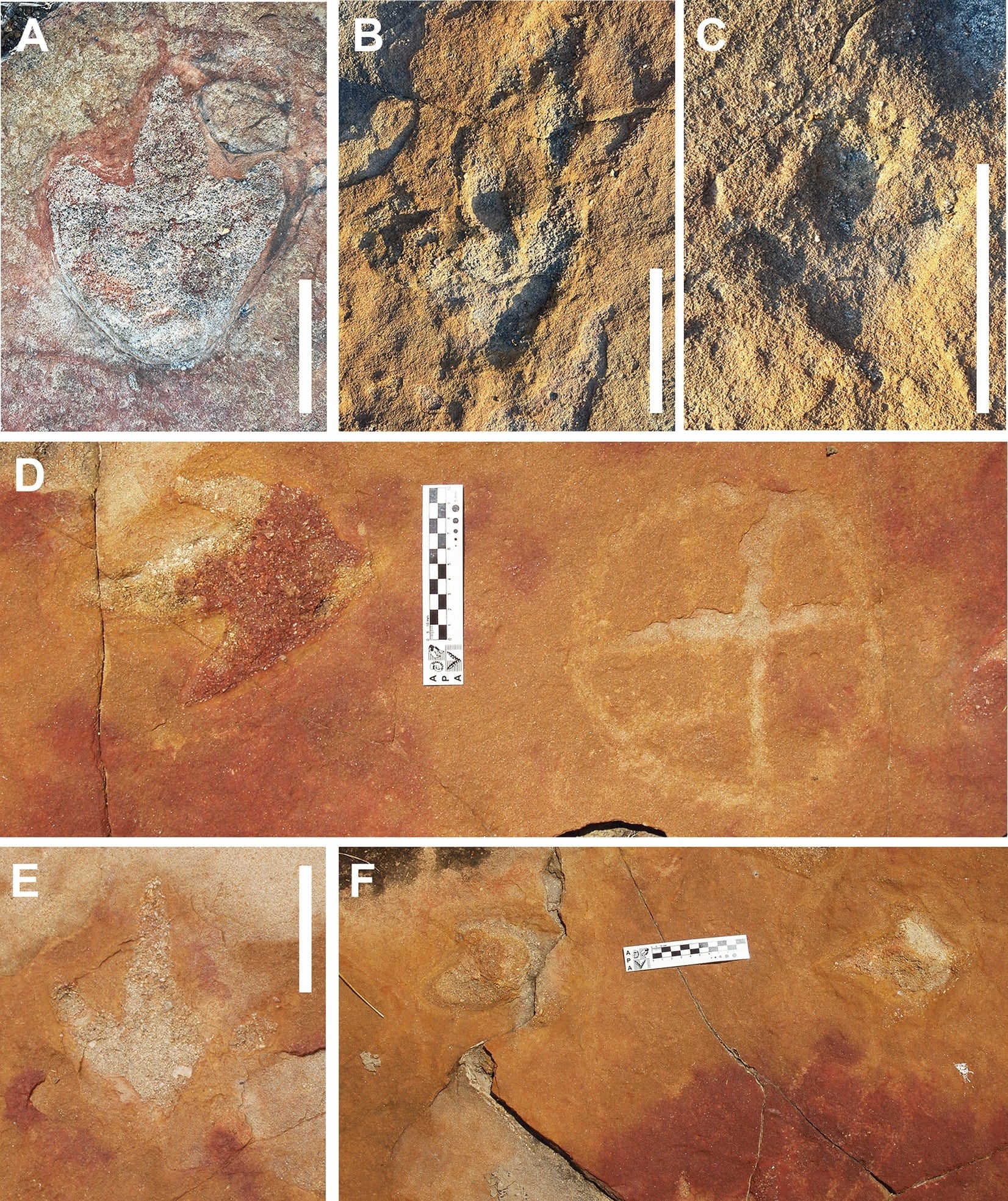
The photograph is panel D of Figure 4 in a 2024 study of Serrote do Letreiro, near Sousa in northeastern Brazil. The researchers identify the mark on the left as a theropod dinosaur footprint. The divided outline on the right is a petroglyph. Someone cut it into stone millions of years after the animal stepped into soft ground. In panel F, a scale bridges a crack between a worn, rounded mark on the left and a paler impression on the right. The researchers identify another footprint and neighboring engraving there. See both panels in Figure 4
Leonardo Troiano and his colleagues argue that the Indigenous engravers recognized footprints here. A circle tells us little about what its maker knew of animals. Where that person chose to cut the circle gives us more to go on.
What actually happened
About 140 million years ago, dinosaurs crossed sediment in what is now the Sousa Basin. Their tracks survive on three low sandstone outcrops among the trees and scrub of the Caatinga. Paleontologists have identified prints from theropods, long-necked sauropods, and plant-eating ornithopods. The clearest evidence for the engravers’ interest concerns the three-toed theropod tracks on the northern outcrop.
The human marks preserve something of the work itself. The engravers scraped grooves in the sandstone and sometimes deepened them with repeated blows from a pointed tool. Little pits remain along some lines. On the northern rock, many of those lines divide circles into sections. The southern rock carries a wider range of designs, including grids, spoke-like forms, and a long winding groove. Related designs and working techniques elsewhere in Paraíba and Rio Grande do Norte are the basis for attributing the carvings to a precolonial Indigenous tradition. Field descriptions and Figures 5–7
Paleontologist Giuseppe Leonardi recorded the site in the late 1970s. By 2000, he and Ismar de Souza Carvalho had published a photograph of a theropod print beside an engraving. The work that changed the question came in 2023, when a team of archaeologists and paleontologists walked the outcrops in both directions and photographed them from the ground and by drone. Their survey covered the exposed surfaces without excavating beneath them. In March 2024 they published their map and photographs in Scientific Reports. In April, Brazil’s national heritage institute, IPHAN, announced that it had updated the site’s registration. Earlier photograph · 2024 field study
Key claims and evidence
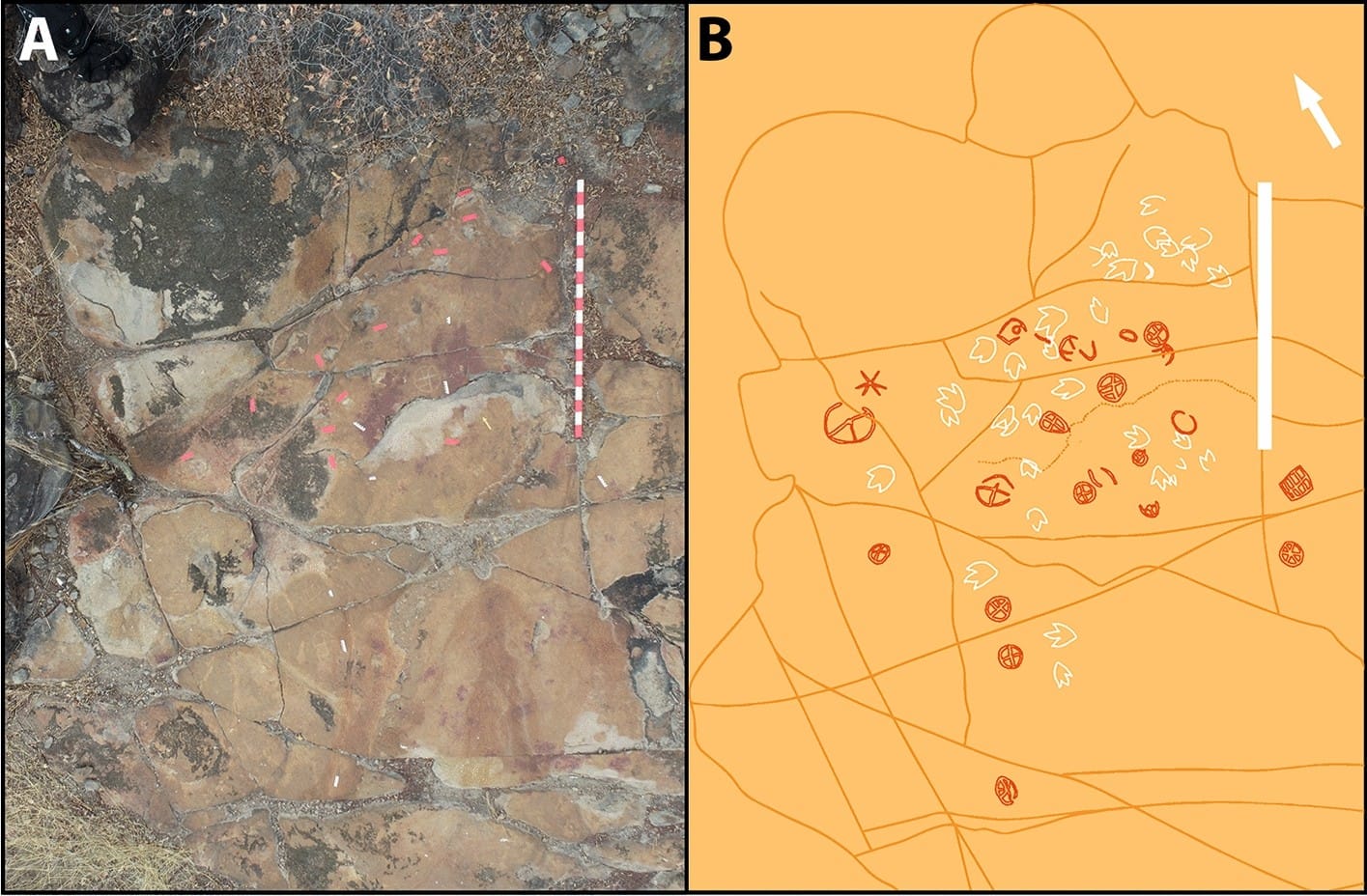
Figure 3 pulls back from the two marks in the opening photograph. On the left is an aerial view of the northern outcrop. On the right is the team’s tracing of that same surface, with theropod prints in white and engravings in dark orange. Near the top, several white tracks cluster together. Farther down, divided circles sit among prints pointing in different directions. A rectangular grid sits off to the right. The two-meter scale gives a sense of how much room there was to choose from. Figure 3
The team reported 22 recognizable symbols on the northern outcrop. Many occupy its central patch, where the theropod tracks concentrate. Some petroglyphs came within about 10 centimeters of a footprint. Across the surveyed site, the researchers found no engraving that crossed or damaged a fossil track. A photographer can always frame one striking pair. What makes deliberate placement plausible is how often the cuts approach identifiable tracks while leaving their outlines intact. Survey results
The other two outcrops give that argument a boundary. The team identified only two poorly preserved carvings on the middle exposure. The southern outcrop held 30 petroglyphs, most on areas with no visible fossil tracks. A few lay beside the broad, rounded prints of a large sauropod trackway. Most of the southern designs would be hard to explain as responses to a nearby footprint. Southern trackway, Figure 8 · Detail, Figure 9
Points of tension
Imagine trying to keep an even groove while cutting a circle. A smooth patch between two hollows offers a better working surface than the broken edge of either one. The hill also stood near a small lake and a seasonal stream. The researchers describe other places in the region where engravers favored sandstone near water. People had practical reasons to use this hillside, even before we ask what they made of its footprints.
Weathering has altered the pattern available to count. The team saw lines too faint to identify and places where a sheet of sandstone had flaked away, taking part of a carving or print with it. Their map records what survived. The study offers no calculation of how often a design would land near a track if an engraver simply chose workable stone. The concentration in the north makes attention to the tracks plausible. Leaving a hollow intact, on its own, tells us little about what a person thought had made it. Surface damage, Figure 10
Perspectives and explanations
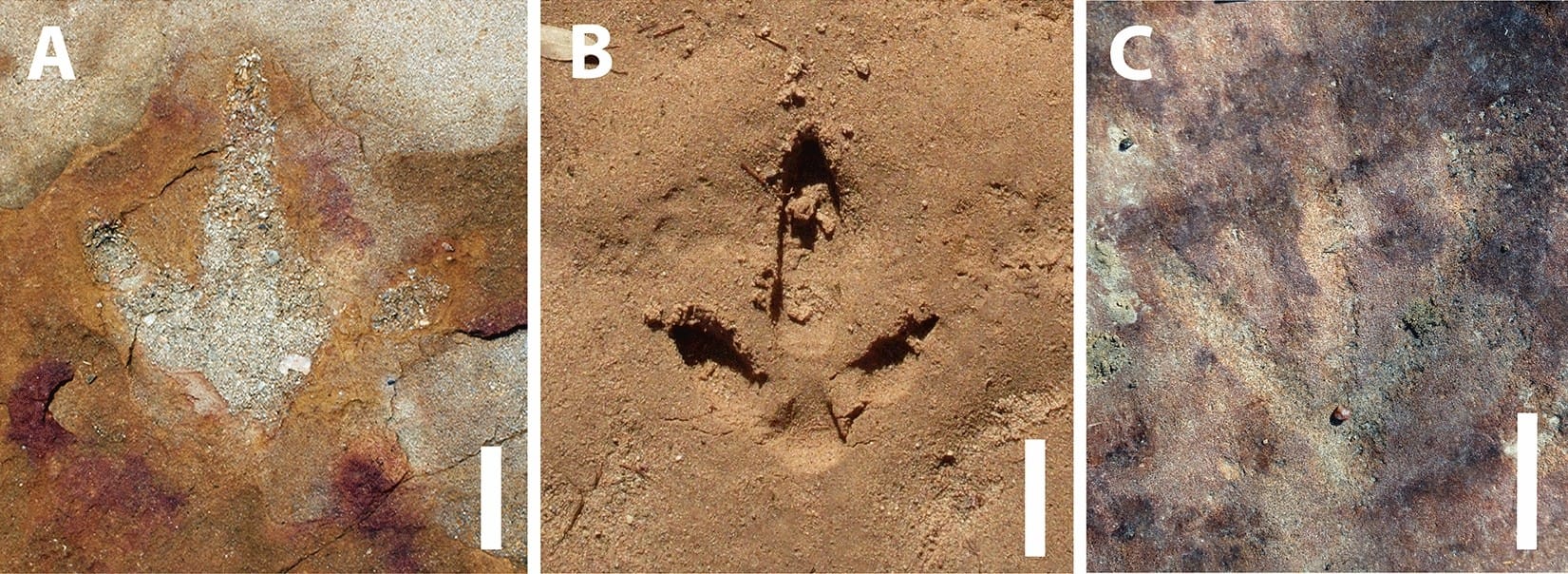
Figure 13 (below) sets three photographs beside one another. The first shows the northern theropod track also pictured in Figure 4E. The second shows a modern bird’s print in loose earth. In both, a middle toe extends ahead of two toes that angle out to the sides. The third shows a three-pronged engraving from the southern outcrop, also pictured in Figure 7G. The researchers brought these shapes together on the page so we could compare them across outcrops and across time. Figure 13 · Figure 7
The authors suggest a familiar animal that could have made the shape legible. The greater rhea (Rhea americana) is a large, flightless bird that lives in Paraíba. Someone who had followed its tracks would know how three separate toes register the weight of one foot. That knowledge could carry over to sandstone and to an animal they had never seen. The figure caption identifies the modern example only as a palaeognath bird track. The greater rhea is the authors’ proposed local comparison. Authors’ discussion
A sauropod print poses a different problem. Its rounded outline lacks those three spreading toes, and the team could point to no close equivalent among living Brazilian animals. They considered whether Notiomastodon, an extinct relative of elephants once present in the region, might have provided a comparison. To make that case, we would need evidence that these engravers knew the animal or its tracks. With the carvings undated and so few southern motifs close to the sauropod trail, the authors were cautious about calling those particular placements deliberate.
Context and pattern recognition
Three prongs can be familiar in more than one way. Valdeci dos Santos Júnior, a regional archaeologist who took no part in the study, told Pesquisa FAPESP that three-pronged carvings are common in northeastern Brazil. A sign of that shape might evoke a bird’s foot, another animal’s track, or even a branching cactus. A person could have chosen a familiar sign for a place beside an unusual footprint. That leaves open whether the sign itself was a drawing of the foot. Interview with dos Santos Júnior
There is an example of such recognition elsewhere in the Sousa Basin for which names do survive. At a different tracksite on the Peixe River, Leonardi and Carvalho recorded local people calling one dinosaur trail the tracks of an ox and another the tracks of an ema, or rhea. Those names preserve comparisons that later residents found apt. We have no equivalent account from the person who cut the divided circle at Serrote do Letreiro. Leonardi and Carvalho’s account
Implications: reality check
The age often attached to the carvings comes from another place. At Pedra do Alexandre in neighboring Rio Grande do Norte, charcoal associated with burials yielded radiocarbon ages from about 9,400 to 2,620 years before present. Those measurements help establish when people used that burial shelter. To date a particular engraving at Serrote do Letreiro, you would need a sample or a securely dated layer physically tied to the cutting of that groove. Similar designs across a region cannot supply that missing link. Burial dates, table 4.6 · Study of the dated material, p. 117
A way to sharpen the placement argument would be to map the usable blank sandstone with the same care given to the marks. If engravers repeatedly chose places next to recognizable prints when equally sound stone was available farther away, that would strengthen the case that the prints guided their choice. Even that result would tell us where an artist wanted to work. Recovering what the artist called the animal is a different task.
The unresolved ledger
What is documented
Field photographs and a scaled map record fossil tracks and Indigenous engravings on the same sandstone. Some northern marks lie about 10 centimeters apart. The survey team reported no overlap between carving and footprint.
What is claimed
Troiano and his colleagues argue that the northern engravers chose positions around the tracks and probably recognized them as footprints. They interpret one three-pronged carving as a possible rendering of a track and suggest the greater rhea as a clue to recognition.
What remains unresolved
The carvings lack direct dates. Which creature the engravers pictured and what the motifs meant remain open. It is also uncertain whether the handful of southern engravings near sauropod prints were positioned with those tracks in mind.
Why it still matters
A museum could preserve the circle and the footprint as separate specimens and lose the most telling thing about them. It is the space someone left between the two, repeated elsewhere on the northern rock, that allows a question about observation to survive at all.
The Galactic Mind perspective
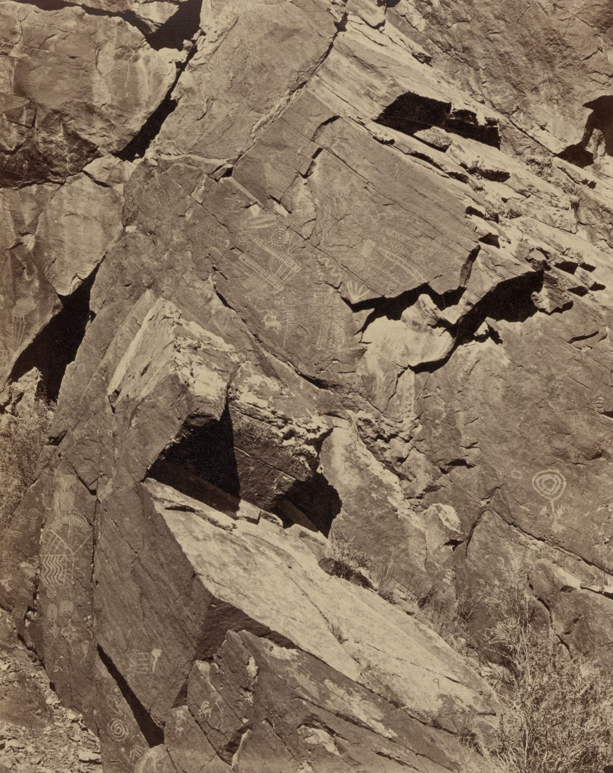
The Brazilian researchers mention Parowan Gap in southern Utah, where Indigenous engravers carved designs into the sandstone walls at the Narrows. Those carvings, at the west end of the pass, remain important to Paiute and Hopi people. The dinosaur tracksite lies near the east end, about two miles away by road.
On the northern outcrop at Serrote do Letreiro, a ten-centimeter scale fits between a three-toed print and a divided circle. The circle looks little like a foot. Its position suggests the engraver noticed the toes when choosing where to work. Someone who knew the tracks a rhea left in soft ground might have recognized a footstep in stone. What animal came to mind, and what the circle meant to the person who cut it, remain unknown.
Open question
What could an engraver have left beside those three toes that would let us recognize the animal they pictured?
More in Case Files
- Trans-en-Provence: The French Landing Trace That Refused to Explain Itself — Another investigation in which a mark on the ground can be documented more securely than the identity of its maker.
- The 1561 Nuremberg Sky Battle: What Did Hans Glaser Record? — A printed image preserves the shapes an artist chose and invites a separate question about what anyone actually saw.
- Alexander the Great’s Sky Signs: Did Ancient Armies Witness Unknown Phenomena? — A source-by-source inquiry into how later interpreters supply identities for things described very differently in older records.
Sources / Receipts
- Leonardo P. Troiano, Heloísa B. dos Santos, Tito Aureliano and Aline M. Ghilardi. “A remarkable assemblage of petroglyphs and dinosaur footprints in Northeast Brazil,” Scientific Reports 14, 6528, March 19, 2024. The primary field report for the photographs, survey map, preservation observations, and interpretation of the carvings. Full paper
- Giuseppe Leonardi and Ismar de Souza Carvalho. Their SIGEP account, dated 2000, includes an earlier photograph of a footprint beside an engraving and records local names at a separate riverbed tracksite. Leonardi’s retrospective places his Serrote do Letreiro find in July–August 1977. The 2024 study gives 1979 for the expedition, hence “late 1970s” in the article. SIGEP account and photograph · Leonardi’s retrospective
- Instituto do Patrimônio Histórico e Artístico Nacional. April 2024 notice documenting the updated site registration. Its discussion of what the engravers recognized draws on statements by members of the study team. IPHAN notice, in Portuguese
- Letícia Naísa. “Indigenous peoples made engravings alongside dinosaur footprints,” Pesquisa FAPESP, May 2024. Includes regional archaeologist Valdeci dos Santos Júnior’s independent assessment of three-pronged motifs. English edition
- Gabriela Martin, Pré-História do Nordeste do Brasil, table 4.6, and André Luiz Campelo dos Santos and Henry Socrates Lavalle Sullasi, Fumdhamentos XIII (2016), p. 117. The table gives the Pedra do Alexandre radiocarbon results. The later paper identifies the charcoal associated with the burials. Date table · Dating context
- Christine Wilkerson. “GeoSights: Parowan Gap, Iron County,” Utah Geological Survey, May 2018. Local source for the gallery and tracksite geography, road distance, and the gallery’s significance to present-day Paiute and Hopi people. Utah Geological Survey


Discussion